Introducing D-Space, Italy's groundbreaking app designed for SAPR pilots and drone enthusiasts. This innovative tool simplifies safe and legal drone operation by providing real-time access to crucial flight information.
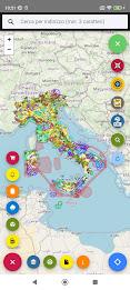
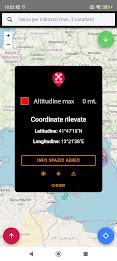
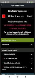
D-Space offers a continuously updated map displaying essential flight data layers, including Controlled Traffic Regions (CTRs), designated takeoff and landing corridors, and monthly NOTAMs (Notices to Airmen). Simply select a location on the map, and the app instantly generates the necessary flight information. A dedicated documents section provides easy access to all required paperwork, ensuring a smooth and compliant flight experience.
Key Features of D-Space:
-
Comprehensive Flight Data: Access detailed information on permitted flight areas and required permissions. D-Space is Italy's first app of its kind, ensuring accurate and current data.
-
Dynamic Mapping: A constantly updated map displays CTRs, takeoff/landing zones, no-fly zones, and monthly NOTAMs, providing a clear visual representation of flight restrictions.
-
Intuitive Interface: The user-friendly design makes planning and executing drone flights effortless. Simply select a location, and the app delivers all necessary information.
-
Real-time Updates: Stay informed with continuous updates on regulations and airspace changes, ensuring compliance with legal requirements.
-
Centralized Documentation: Easily access all essential flight documents in one convenient location.
-
Prioritizing Safety: D-Space prioritizes safe and legal drone operation by providing comprehensive information and resources.
Conclusion:
D-Space transforms drone flight planning and execution for Italian SAPR pilots and enthusiasts. Its comprehensive map, real-time updates, and user-friendly interface make it an indispensable tool for safe and legal drone operations. Download D-Space today and take to the skies with confidence!