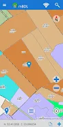
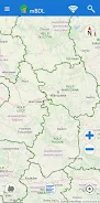
Introducing the mBDL mobile app: Your comprehensive forest data resource! Access detailed forest maps directly on your phone or tablet. This app provides a wealth of thematic maps, including base maps, tree stand locations, ownership details, habitat information, plant community data, hunting areas, tourism development plans, and fire risk assessments. You can also overlay raster backgrounds like topographic maps or aerial/satellite imagery.
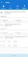
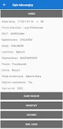
Download data for offline use, perfect for fieldwork in remote forest areas and national parks. Beyond maps, access complete forest taxation details for all ownership types, including tree species, addresses, and economic indicators. The app includes tools for area and distance measurement, GPS tracking, route recording, and navigation. Export waypoints and routes as KML files for easy sharing. Search for forest divisions using addresses, cadastral parcels, or coordinates. A user manual is available to guide you through the app's features.
Download the mBDL app today at https://www.bdl.lasy.gov.pl/portal/deklaracja-mbdl
App Features:
- Direct access to forest maps on mobile devices.
- Extensive thematic maps covering various forest aspects.
- Support for raster backgrounds (topographic, aerial/satellite) and external WMS services.
- Offline map access for use in areas without internet connectivity.
- Online access to detailed forest taxation descriptions.
- Integrated tools for measurement, GPS recording, route tracking, and navigation.
Conclusion:
The mBDL app offers unparalleled access to forest data and mapping tools. Its diverse map options, offline capabilities, detailed taxation information, and practical measurement/navigation features make it an indispensable resource for foresters, landowners, and nature enthusiasts. Download the app now for a seamless forest exploration experience.