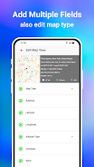
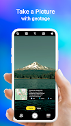
This GPS Map Camera app cleverly integrates camera functions with precise GPS location tracking. Features like geotagging, GPS scanning, and GPS mapping let users visually document their journeys. The app boasts a powerful mapping system for viewing photos on a GPS map, creating a visual log of your adventures. Beyond its camera capabilities, it allows adding GPS location data to existing photos, transforming your image collection into a location-based photo map. Its user-friendly design works flawlessly with GPS-enabled devices. Whether you're a professional or a casual photographer, this app is a valuable tool for adding geolocation information to your photos.
The GPS Map Camera App offers six key benefits:
-
Integrated Camera and GPS: Capture photos while simultaneously geotagging them with precise location data, creating a visual travelogue.
-
Versatile Photo Capture and Tracking: Use the built-in GPS camera or add location data to existing photos using the app's geotagging feature.
-
Comprehensive Mapping: Easily view your photos on a GPS map to see where each picture was taken along your route.
-
Customizable Date/Time Stamps: Choose and add date and time stamps to your photos for precise record-keeping.
-
Photo Organization Tools: Customize photo names and use live navigation to efficiently manage your image library.
-
Lightweight Option: The Lite version provides many of the full app's features while using less device storage.